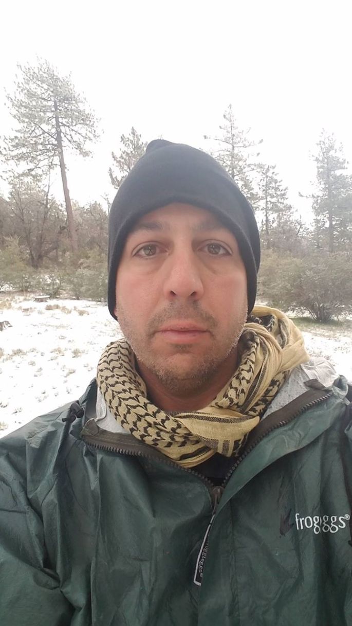
The clock is counting down before I set off once again on the Pacific Crest Trail. That mystical place that calls on me and pulls at my heart strings. It is Friday night and we decide to go to Olive Garden, you know to carb load. Our experience is less than spectacular. I am unable to finish my pasta and the desert was, well, frozen solid. We left disappointed at our meal but I was excited on what was to come the next day. Shortly after getting home and doing one final check it was time to get some rest, tomorrow would be brutal. Then at midnight I awoke feeling ill. This could not be, I could not go down for an illness. I tried to get some more sleep, but it was here and there and with little rest.
Saturday morning is here and it is time to get going. I was not feeling 100% but confident it would not hinder my journey. Arriving at the PCT I felt a sense of purpose, a meaning to this journey I was about to continue. As the pack settled on my hips and shoulders it was time. Then with one step the Trek4PTSD was back on the trail, back on the PCT and back to sending awareness for PTSD and mental illness. Overjoyed does not begin to describe the feelings going through me.
As I set off, once again, on the PCT the day was perfect. Not too hot and not too cold, the sun beating down enough to remind you it was there and the trail welcomed me like an old friend. As Hwy 74 disappeared beyond the winding trail I wondered what the next two days had in store for me, who would I meet. During the last mile on the road, we saw a few hikers, would I run into them again?
This slideshow requires JavaScript.
At first, my pace was great at roughly 2.5 miles per hour. If I was able to maintain that pace, I could easily make my goal for the day. Then I heard voices, well more like shouts of joy. I wondered if they could be the 3 hikers I had seen on the road, but they didn’t seem like the kind to yell that way. As my pace began to slow, I could hear them getting closer. The hikers were not the ones I had seen but others that must of camped just short of Hwy 74. These 2 individuals were the most lively, friendly, warm and happy hikers I had ever met. Tony and Choy were their names. Tony is from Hong Kong while Choy is from South Korea. Their English was a bit rough and I am not sure if they both spoke the same language. Regardless of this barrier, they seem to communicate with each other relatively well and they did not allow it to impede their communication with other hikers. They passed me and continued on. Not too long after that the 3 hikers I had seen on the trail passed me by and went their way.
Roughly six miles into the hike it was pushing mid-day. I had reached the first spot for water on the trail. This meant ditching my pack and “slack-packing” the third of a mile off trail to get water. This was a steep descent to the spring. Once I arrived at the spring I drank all the water I had taken down with me and proceeded to fill my “dirty” water bag and filter the water. The cool water was refreshing and now comes the daunting task of making my way back up the trail to where I left my pack. There I met back up with my two friends from Asia as well as two young ladies, one from Boston and one from England. I sat around for about a half hour talking with those who passed by, my two friends and the two ladies. At some point my two Asian friends set down the trail to get water. In the meantime, a young man from Denmark arrived and had his lunch. He too set down the trail and came back up. Upon his arrival we asked if he had seen Tony and Choy since it had been so long since we last saw them. To our surprise, he had not. The conclusion was that they took a different path and should be back soon. I set off not knowing the faith of these two happy, go lucky guys.
After setting off from my short break, the going began to get rougher. The trail began to get steeper and higher. By now I was over a mile above sea level and climbing. Every few hundred yards were met with a short break, sometimes shorter distance and longer break. My long and tiring ascent meant that hikers I had barely met during lunch were now passing me by. And then, to my surprise, came Tony and Choy. Their wrong turn getting to the spring had earned them the trail names of Missing 1 and Missing 2 respectfully. They made it possible for me pick up the pace if just for a little bit. For that short while my pain was alleviated. But as quickly as they caught up with me, they were off again. I wondered if I would see them again, maybe at camp that night. As my pace slowed I doubted that I would ever see them again and my chance to capture their enthusiasm in a photo had gone with them as well.
The day was getting late and the trail was still steep. With that the thought of finding a camp site was foremost in my mind and I wanted to see if I could catch up to Tony and Choy. I could see the sun beginning to set and the downhill helped me speed up to find camp. Then, as I turned the corner I saw two tents next to a boulder. My concern was that there would be no space and it was well founded. The two individuals, Paul a Britt from Australia and the other gentlemen who’s details I cannot remember, said that there was no room but to check on the other side of the boulder. There was another hiker who was South Bound on the other side of the boulder. There was just enough room for my tent and with no rain in sight I did not put up my rainfly.
As I set up camp I had realized that I had eaten very little that day and was not really hungry. However, knowing that I had to replenish calories, I made dinner while I got ready to call it a day. I cold see Palm Springs, Ca below as the sun set, I could not help but gaze in wonder how beautiful the lite up city looked. I tried to eat, but could not finish my food. I wondered if the dinner the previous night was the reason for my lack of appetite. As I finished my evening meal, I turned in for the night.
This slideshow requires JavaScript.
The night was not kind to me. I tossed and turned most of the night, not to mention that I woke up half a dozen times to go to the bathroom. This seems to be a problem for me on the trail since I have no need to relieve myself during the day and it all hits me at night. Every time I awoke my legs cramped up and I could barely walk straight. This was not a good sign for the next day. I took pleasure in the view down the mountain of the city lights while I made my way to where I needed to go and upon my return I could see the stars above me while I drifted away into sleep. Sunday morning came with a beautiful sunrise. My legs, which I was sure would be in knots by morning, were fresh and ready. I boiled some water and dug in my food bag for what would be breakfast. But once again, no appetite. I could not drink my coffee or eat my breakfast. With that realization, I broke camp and began heading down the mountain. I knew that in less than a mile I would have to begin another grueling ascent, something I was not looking forward to.
As I made my way up the final mountain I knew that once I crested it the rest of my hike would be down hill. Originally, the plan was to hike the detour all the way to Idyllwild, Ca. But sometime the previous day I had made the decision that if I was not on the PCT, that there was no reason to be out specially if it was a makeshift trail to get PCT through hikers the ability to bypass the 8 mile fire closure. This decision made the day seem a lot better, no need to rush to make it to town and then drive the two hours to get home. I needed time to recover that evening.
As the 2 mile ascent continued, my body grew weaker by the minute. Almost two thirds of the way up, Paul and his hiking buddy caught up with me and I did my best to keep up with them. Their pace was too fast for me and they quickly vanished up the trail and switchbacks. Then, I reached the top. From here I could see to the east Palm Springs and the Palm Desert, and to the west Lake Hemet and San Diego County. Paul and his buddy had taken a break and I passed them by. Just a few hundred yards past the two of them was the fire closure and what would be the end of the PCT for this trip. The view was so wonderful that I tried to go live on Twitter and Facebook, but the signal was too weak. I was barely able to call my wife to tell here when and where to pick me up. As I was on the phone, Paul and his companion headed on down the detour.
Fire Closure
PCT Detour Tail Marker
Lake Hemet
After wrapping up my phone call and taking some pictures, I looked down on Lake Hemet and pondered the 7 mile 4000 ft descent that was in front of me. I stepped off the PCT and headed down the trail to my extraction point. Along the way I would pass Paul and his friend, then they would pass me once again. The descent was uneventful and I was doing 2.5 plus miles per hour. At times the steep descent would be painful but bearable. Five miles later I reached the end of the trail and onto a surface street. The hard pavement would send my feet into pain unlike anything I had experienced on the trail. Then the last three quarters of a mile I was joined by Mark from Sweden. We chatted a bit about the way things are in his country, the hiking/kayak trails and his hopes of finishing the PCT. He continued on the detour while I made it back towards Hwy 74 and Lake Hemet. Suddenly I hear someone yell my name, it was Paul. They had spoken to the park ranger and the rangers father was going to give them a ride into Idyllwild.
I finally made it to Hwy 74, dropped my pack, took off my boots and put on my camp shoes as I waited for my ride. As I sat by the side of the road I felt sad that I had not seen Tony and Choy before I went home. There are some people on the trail that you are immediately drawn to, these were my two for this trip. I was sad that I would not see them again and that I would only have my memories of them to serve as a reminder. How much I wish I had seen them one last time. Just as I was emptying my mind and relaxing by the side of the road I see two hikers making their way around the curve back towards the trail, they were coming my way. Once they came into full view I recognized the big blue backpack. I could not contain my excitement and yelled out “TONY, CHOY”. Upon realizing it was me they yelled back the best way they could, my name, “RAUL!”. For a couple of minutes we talked the best we could and took the pictures I longed to have. And as with any selfie, they had to take their own as well. We hugged, shook hands and went our different ways. It was the perfect sendoff for my weekend trip.
Left to Right: Raul “Section 8”, Tony “Missing 1”, & Choy “Missing 2”
Once I was picked up by my wife and son, we headed home but not before getting some Epson salts and a big greasy burger from Calr’s Jr. We made our way home and I took a long bath to calm my aching muscles. It was now time to prepare for the next trip…how long could I stay out and how long could I go.
One thing I thought about during this trip was how much the trail and mental illness are alike. They are both a journey that will have difficult sections that will make you want to quit. However, along the way you will find that there are people who love and support you on your journey and will do what it takes to make it a success. There are people who know that you are on a difficult journey and will help you with supplies and support along the way. And most important is those on a similar journey who will lift your spirits when you are down and who know what it is that you are going through. They will help you in any way they can while they walk alongside of you. There are many times on this journey that you will want to quit, but if you stick with it the beauty of the next sunrise will be your reward.
NEVER QUIT FOR TOMORROW A SUNRISE IS WAITING FOR YOU!
#TREKON
30 March 2016: Trek4PTSD Zero Day 2; Camp Pendleton, Ca.
The day started with a sense the feeling that I had some unfinished business. The morning prior I had left Mount Laguna with the feeling of defeat. The decision to leave the mountain the day prior was the right one, but it did not help. As I typed away, recounting the previous days I wanted to go back, I needed to go back. The time was there and I could go back and finish this leg, I would not be defeated.
Later that day the decision was made. I asked my wife if she could take me back the next morning and drop me off where I had stopped. Without hesitation she said yes. Now it was a mad scramble to put the lessons learned in the previous three days into action and adjust my pack. In an attempt to save a few precious ounces, about four, I checked REI’s website to see if they had received the Therm-A-Rest Z-Lite mat, they did. We rushed there and purchased the new mat. A stop at the grocery store to buy a couple of bottles of Smart Water to replace the heavy Nalgene bottle, again a savings of probably two ounces which were replaced by the additional half liter I was carrying.
With all purchases made it was time to repack and get some rest. The next day would have me back on the trail.
31 March 2016: Trek4PTSD T-0:30; Sunrise Trailhead Parking Area
Having prepared for the journey ahead, I had consumed large quantities of water and Gatorade. With just 30 minutes before the journey would continue, the amount of liquid I had taken in had to start coming out. We pulled over into the trailhead so that I may use the bathroom. There, as we pulled in, we noticed another PCTer. He looked familiar and I asked, “Is that Brad?” Much to my surprise it was. I was very excited to see him and a sense of sadness came over me. I knew his end goal was Warner Springs and at best that was two and a half days away. His goal was to make it there by April 1st where his wife would pick him up. He would not be able to finish and would only make it as far as Scissors Crossing, 32 miles short of his goal. The storm that forced me off the mountain had put a major roadblock in his plans. The silver lining was that he would be able to continue down the mountain and do the best he could. As if the storm had not been enough of a stumbling block, one of the major support poles for his tent had broken and he was not set up to go Cowboy Camping, the previous night he had slept in the outhouse away from the elements.
But the time to catch up had to be caught short. He had wondered where I was and seemed glad to see me again. I could not pass up this opportunity to see this trail friend of mine once again without capturing the moment. With phone in hand I snapped a picture of the two of us so that I may remember this fellow PCTer.
Brad & Raul
Trek On Brad. I am certain you will be back and will continue on your journey. Now it is time for me to continue on mine.
31 March 2016: Trek4PTSD Day 4; Mile 47.5; Mount Laguna Campground
The time come as we arrived at the exact same spot that I had left the trail. A scenic overview platform that gave a magnificent view of the desert floor below. The temperature was in the low 30’s and I had just a t-shirt and light pullover on. Better to start off cold and warm up, than to start warm and sweat. That could lead to being colder than I would of been without it. I strapped on my pack and had to pose for a picture with the desert behind me. As I stepped off I would encounter two PCTers who spent the night just below the platform. They did not know that the campsite was just less than a half mile up the road. After talking to them for a few minutes, I was on my way. Leaving, I said the required phrase, “see you when you pass me up” believing that it would be so. I did not see them again.
As I made my way down the trail I was glad I made the decision to not continue on Tuesday. With the storm gone, the views were breath taking. I gazed at the desert below and the cool wind made the trek that much more easy. Time seem to go by slow, but the miles were flying by. In just a little over two hours I had made it to Pioneer Mail Trail Picnic Area, named for the pioneers of the mail service who made their way over the mountains to bring the mail out west. Upon my arrival to take a short break, I saw two hikers in the park. One of them was getting in a mini van and the other was getting ready to get back on the trail. The one getting in the car was the girl I had met on day one less than a mile into the journey. She is the one that walked four miles in the wrong direction. I did not have the opportunity to talk to her, but I finally learned her name, Rainbow. She was headed back to Mount Laguna to return the sleeping bag she had exchanged at the outfitter store there. Come to find out that she had not slept for two days and when they looked at her sleeping bag up against the light, they could see patches where light was shining through. Also, later I found out that her budget for the entire thru hike is very small. Her luck in the first 53 miles has been disastrous and I fear for her on the trail. I hope that she finds better luck on her journey.
Here is also where I met Sheppard. He earned his name on day one when he ran across another PCTer who didn’t look too hot. After about half a mile after passing his fellow hiker, he decided to wait for him and make sure he was alright. The hiker he waited for had only brought two liters of water for the first 20 miles, a substantial low amount of water for such a long stretch without a reliable water point. Sheppard gave the hiker some of his water and stayed with him, or “shepparded” him until he could get more water. Sheppard is from the outside of Richmond, Va. and seemed to be in his late teens or early 20’s. I would see him again at camp that night.
As I continued on the trail I would run into one of the funniest and most entertaining characters so far. I had met Rebo at Lake Morena on day two just a few minutes prior to leaving. He is from Pasadena, Ca. and probably in his late 50’s or early 60’s. I deduce this based on his stories, but I cannot be certain. As far as his name, that is unclear as well. He explained that he got it from a folded piece of cardboard that they saw along the way. His stories made for great dinner time entertainment and he had met plenty of people in his prior hikes. It also appeared that he was taking video or pictures at every turn and is working on a YouTube channel that he hopes to call something along the lines of PCT Water Report. Having already done a thru hike of the PCT, he was only doing a fraction of the entire trail with the Class of 2016 and is planning to hike the CDT in 2018. I look forward to his channel and hope to run into him some day.
Rebo & Raul
As I passed mile 54 I was startled by someone saying “behind you”. Without making a noticeable sound, or just through sheer speed, a group of six cross country runners passed me by. Shortly after that four girls from the same high school team passed me and then their coach. I was impressed by how well they were handling the altitude and environment. They would run past me again going the other way. My understanding is that they were a team from Massachusetts. A mile or so later they would pass me again going the other way.
I would pass Rebo once more before arriving at mile 59.5. This is where I would detour off the trail to get some water. I arrived at the Sunrise Trail head about a third of a mile off the PCT. This is where I saw Brad earlier that day. I walked up to the tank and filled my Gatorade bottle with water. Spent a few minutes relaxing with my pack off before making my way back onto the trail. Where the Sunrise Trail and the PCT meet, I ran into Rebo once again as he was taking some video for his YouTube channel. Once more I was on the PCT.
As I continued on the trail Rebo, the seasoned hiker, would pass me up once again. There were about four miles to what I thought would be the campsite for the night. That would of made it a 14 mile day. However, Rebo would convince me to keep going to his destination for the night. As I passed mile 63.7 I saw what was originally going to be my campsite. It was a beautiful little spot that would of provided a wonderful home for the night. I had given my word that I would continue and as I made my way uphill on the Jeep road. Just a few minutes into the uphill trek I began to question my decision. But there is no going back on the trail, so I pushed forward.
At around 1830 that evening, I made it into camp where Rebo was just finishing up with his tent. He looked at me and said, “told you, you would be here by 6:30”. I found an area hidden by one side by bushes providing some cover in the event of some winds. I was glad I made it to this little spot, it provided great views and most important, water. Since I had filled up with water at every opportunity and in no real need of water at camp that night. Once I set up my tent it was time for some dinner. I pulled out the bottle of Gatorade that I filled with water that needed to be filtered. Finally, here is where the water filter comes into play. The water was clear to begin with, but there was a warning to filter it, so I did. When the water made its way through the filter it came out gray and foamy. I knew this was due to using the filter for the first time and the grey color was carbon and that won’t hurt me. That night I would eat good, have great conversation and most important it was a quiet night. The only downfall, besides getting up to go to the bathroom, was that in the 45 degree night I would wake up sweating. Simply taking out the silk liner and changing my shirt would be enough to make the night comfortable again. It was the first real good night of rest I would have on the trail after an almost 21 mile day.
1 April 2016: Trek4PTSD Day 5; Mile 68.4; Rodriguez Spur Fire Tank Campsite
After a good night of sleep it was time to wake up and get the day started. Before exiting the tent, I changed into my hiking clothes and packed what was in the tent. It was just before sunrise when I exited my tent and everything was great. I started to get my breakfast ready, just some oatmeal and coffee. As I waited for breakfast to be ready it was time to break camp. The sunrise was beautiful and the moment had to be captured. This was the first time that I had been able to witness the sunrise and one of the things I had looked forward to since planning began. This sunrise is nothing compared to those that I am sure to come, and am looking forward to them. The picture did not make it justice, but it is a start.
As I enjoyed my breakfast and studied my map for the day ahead one of the hikers, Hardway, made his way back on the trail. I was the second to leave camp. This would be the last time I would talk to Rebo, Sheppard and the other PCTers that spent the night there. It was time to get back on the trail and make my way down the mountain.
On my way down I would run into Hardway again. I had met him on day two at Lake Morena. His story is still a mystery to me, but I did enjoy his company even if for just a few minutes. On the way down we would meet two day hikers who were heading up the mountain. They would be the first of many day hikers I would meet over the next couple of days. As I made it to level ground I ran into Major Tom who had been following Hardway’s progress through Rebo’s Facebook page. They had hiked together the previous year and it seemed like two brothers who had not seen each other in years meeting up again. Hardway was having problem with his feet, so he rested with his old friend while I carried on.
As I approached Scissors Crossing I ran into my first big water cache. Just short of mile 76.5 is where this bit of Trail Magic appeared under some small bushes. In the distance I could see the trail I would be going up and made the decision to fill up on water in the event that I would not be able to get more water on my way up. I also knew that the next reliable source of water was 15 long, hot, uphill miles ahead. Half a mile later I would run into a couple waiting for their PCTer cousins. They were part of their trail support and lived a few miles away. I spent some time talking to them and in doing so I noticed a shotgun shell sticking out of a pipe. While I was not looking for a cache and did not have my GPS with me or my phone out I decided to check it out. I pulled the shell out and to my surprise there was the log. This little treasure made the day a bit more fun. Once again I was on my way.
Just a few hundred yards after leaving the couple and the cache I arrived under the bridge at Scissors Crossing. This was a planned stop for lunch. I was out of the sun and ready for a nice hardy lunch before the steep ascent and all the switchbacks. Once again I came across even more Trail Magic. In this case someone had even left a four pack of beer, a can of Pizza Port beer, a couple of cigarettes and it appeared that they had left some other goodies that had been taken/eaten. Here I would log my cache, cook my lunch, text my wife and most important, wish my mom a happy birthday. Once my lunch was ready I pulled out some Gatorade powder and proceeded to enjoy my lunch before setting off.
As I step off from mile 77 it was time for my last big ascent. I had just a little over 1,700 feet to go up hill. This area was familiar to me since it was the road we would take to go Jeepin’ out in the desert. Making my way through the switchbacks I would see the S2 the entire way up. Every time I would make it past a switchback, I would make a mark on the map to ensure that I was accurately accounting for my location. The day prior I was always about a half a mile further back than I was because I was unable to distinguish between the features on the map as I was looking up at them.
On my way up I would see a couple that I had met first on day one and again the night prior at camp. We tried to talk to each other, but the distance between us made it difficult to understand. I believe that they were about a mile behind me on the trail. I was hoping that they would eventually catch up with me where I camped and I would have someone to talk to. As the day progressed I knew that this would not be so.
The sun was getting lower in the sky and time was starting to run out for daylight. Here is where I had to start making decisions. 1800 came and I was looking at where to set up camp. After studying the map my first choice was at mile 85.4. As I arrived in the area I was not impressed with the options and opted to continue a little more than half a mile to the next possible location. It was in a saddle and not the geographic location I would want to set up camp. I arrived at the campsite and scouted out for a good place to set up camp. I was not happy with the location and began to question the decision. I pulled out my phone and called my wife. In the process I knew that if I was not happy with the location and I could continue that I should. Here is where my wife came along with me on the trail, via phone. Once again, just over a half mile to go.
As I arrived at the dry creek bed I was very happy that I had continued on. This location was in a valley with plenty of protection from the wind being provided by the mountains around me. Someone had even made a campfire ring and left some wood, the thought of a little fire did cross my mind, but I never started one. I set up camp and prepared dinner. It was a quiet evening and I spent some time talking to my wife on the phone. The only thing that was missing tonight was some company, but the solitude was pleasing.
The day had provided some great views and beautiful flowers, many of which were cactus flowers. The only downfall of the night was about 0300 when a pack of coyotes came about a hundred yards from camp howling. Besides that it was a very comfortable evening.
2 April 2016: Trek4PTSD Day 6; Mile 86.6; Dry Creek-bed Campsite
Day 6 would begin with a new sense of purpose. With just 500 feet short of 23 miles to the end of section one and another night on the trail, the end was in sight. Morning routine out of the way it was time to set off just a little bit later than planned. There was one thing I was looking forward to today and that was the infamous third gate water cache just four miles ahead. I made my way up the mountain once again and on the trail. Then, shortly after crossing the pipe gate at mile 91.2 I saw the sign. There it was another detour off the trail to water. This time it was just an eight of a mile to go.
For days I had heard of this massive water cache at mile 91 and I wondered how accurate the reports were. I had heard two pallets and I had heard 500 gallons. Could these be exaggerations? Could the amounts be accurate? As I arrived at the location I was amazed. This was true Trail Magic and I am so thankful for the Trail Angels that brought it here for us PCTers. It had only been a couple of hours since my day had began, but I was grateful for what was in front of me. Signs above the water told us which ones to use first, second and last. They also asked for a limit of three liters per hiker and not to use the water for bathing. By my estimations there were anywhere between 400 and 500 gallons of water out here. That also does not include the empties in the used bottle garbage bin that was constructed just a few feet away. So much thought had been given to this oasis in the desert that there were funnels attached to the trees with string so that we could use them to fill our bottles. I filled up with three liters of water and had a snack, again I was on my way.
On my way back to the trail I passed the sign once again and I signed the log that was just under it. I took a few minutes to look at past logs and saw that Haven and Kristen had been there just two days prior. Knowing that they had made it back on the trail made me happy. Continuing to look at the logs I hoped to see some of those that I had met in days prior, but no luck. The rest of my time on the trail I would not encounter another section or thru hiker.
As I continued on the PCT it would be a few more miles until I stopped for lunch. On my map there is a point called Billy Goat’s cave at the 96.1 mile point, this was my planned lunch spot spending about 30 minutes there. As I arrived at my destination I was impressed by the work that had to go into this little cave. My lunch was a high calorie one so that I may continue the journey before me. After I was done I rested my head on the rocks behind me and almost fell asleep. I could of seen myself spending the night in this cozy little cave for one maybe two. My allotted time at this little bistro was done and with everything I had on my back I set off once again.
Roughly 20 minutes after I left the little cave I could see where the trail wound down the side of the mountain. I had was looking across the valley about a half mile but had to traverse almost two miles of trail to get there. From here on out it would be mostly downhill. I took note of the time and started to time my pace. The fastest pace so far was around two miles per hour and that was more or less what I was averaging after day two. The worst was about one mile per hour, so what would my pace be this time. To my surprise I was looking at around three miles an hour and I had over four hours of daylight left. This meant that my estimates for completing section A could be off by several hours. That was yet to be determined.
On my way down the mountain I was heading to Barrel Springs, and on my descent that I reached yet another milestone. It was here, on the side of this mountain that I found the artwork of some intrepid PCTer or a Trail Angel. There, in rocks, marked the 100 mile point on the PCT. This was also where I realized that I was only nine and a half miles from my destination. The end didn’t seem so far. I had exactly the number of miles left on section A that I had covered on day one when I stopped for lunch. Here is where I knew I wold finish today and I would be home for dinner.
As I arrived in Barrel Springs, mile 101.1, I saw what appeared to be sections hikers. The odd thing was that one of them was dragging a cooler. Could it be that someone was courageous enough drag such an odd item through the PCT? I stopped to talk to her, Blondie, and found out that they were doing a gear check and had just come from Warner Springs. They were getting ready to enjoy a few cold ones and some dinner. She offered me a beer, but with just over eight miles to go I could not indulge. Then she asked what seemed like an odd question at that moment. She said, “Do you use Halfmile?” My reply was obvious as many PCTers would have answered the same, “Yes”. This is the moment that she introduced me to one of her hiking companions, Halfmile! It took a second for it to register, but this was the man himself. A sudo-celebrity in the PCT world. The maps that I used were based of his data, the app I would occasionally refer to on my phone was his. I had so many questions that I had thought about on the trail while looking at my navigational aids. He did explain that when he was planning his thru hike of the PCT that he could not find any reliable routes or references. So, in 2014, him and another hiker did the PCT with custom equipment and mapped the entire PCT. The great thing about the app is that at any point on the trail it will give you the distances (crow, trail, etc) to whatever point on the PCT you wish to go to. It will also give you the total elevation gain and loss for the selected destination. It will also give you the information you may need about your destination, as an example coordinates, elevation and description. I wanted to continue talking to him, but I was on a mission and I had to part ways.
Halfmile & Raul
As I made my way across a cattle grazing ground and five and a half miles from the end of the trail I stopped to take out my phone and make the call. As the phone powered on I wondered if I would have signal, I did. I called my wife and told here that I would be finishing today and not tomorrow, something that came as a surprise to her. When she asked what time, my response was between 1830 and 1930. This was a pure estimate and wondered if I would be hiking in the darkness. But I carried on. My phone would remain on the rest of the time. As I crossed this section of the trail I also realized that I would not need close to four liters of water to finish. I reached behind and grabbed the bottle full of water that needed to be filtered, about a liter. These were two pounds that I did not need, so I dumped them out and proceeded on.
Just a short while later I walked up on what was originally my destination for the day. A campsite with plenty of area and a stream cutting through it. This also appeared to be a popular destination for overnight campers, but there was plenty of room. I questioned if I would have enjoyed the evening with so many people around. There were three locations where people had set up camp, the one in the middle seemed to be the one for PCTers but I could not be sure. I passed the last set of campers and crossed the shallow stream, the next stop was Eagle Rock.
As I cleared the wooded hills just past the campsites, there was a vast open space. There, about a mile away, was Eagle Rock. Since day one, this was what I wanted to see. It was this rock formation that I would have been disappointed if I did not reach this week. As I approached the rocks, I could not help but wonder if this was also Brad’s ultimate destination for his trip and how he was unable to see it. As I arrived at Eagle Rock there was a family who had made a day out of going to Eagle Rock, PCTers of years past. I spent a few minutes talking to them and they offered me some fruit and to take my picture in front of the rocks. I was glad for their hospitality and company. Now it was time to complete the last 3.2 miles.
When I was leaving Eagle Rock I encountered a small herd of cows that seemed very interested in me. I pulled out my camera and they were very kind to let me take their picture. Some seemed skiddish while others were fearless and approached me. It was a very interesting experience and apparently one better than some had after I left.
As the sun began to fall behind Palomar Mountain I knew that my time on the trail was almost at an end, this time. I continued to make my way into Warner Springs and followed another stream for a little while. Half a mile from the end of section A was a large beach like campsite with one tent. Another great location with flowing water to set up camp. Someone had set up their tent here, maybe another PCTer? I was not sure since I did not see the fellow hiker, no time to stay and find out. Finally I could see the fire station, the 109.5 mile point of the PCT and the end of the section. I walked up to the gate and unlocked it. Here is where I would stand for a few moments. Stepping over the gate would mean that I was done this time, that I would have to leave the trail. I did not want to cross it. It was now that I understood what I had heard before about leaving the trail. This was a bittersweet moment and one that had to take place. I crossed the gate and dumped my gear waiting for my ride, it was exactly 1900.
As I sat on the retaining wall waiting for my way home I wondered if there was a cache nearby. To my delight there was and only 50 feet away. A great cap to the week. Shortly after, the family that I had seen at Eagle Rock came through the gate and talked with me a bit more. Here is where I found out that the cows were more aggressive with them and chased them for a bit. A funny experience for them, after the fact. It was only a few minutes after we parted ways that my wife arrived and I was on my way home.
Before I stepped into the car I looked across the street and the gate that I would be crossing next to get back on the trail and onto section B. Now there was no time to rest, it was time to begin planning the next chapter.
3-8 April 2016: Trek4PTSD Week After California Section A; Camp Pendleton, Ca
This was the week to start planning the next phase. During this week gear would be exchanged and lessons learned would be put to use. The time to get back on the trail cannot come soon enough, it is now a question of when. The hope is soon. Until then, Trek On!
TREK4PTSD PACIFIC CREST TRAIL CALIFORNIA SECTION “A” SUMMARY
It was the night before and final preparations were under way. Last minute purchases, such as a silk sleeping bag liner, and preparations were being made. A nice pasta dinner at Olive Garden to load up on the carbs I would be needing the next day was part of the plan. One last unpack and repack just to make sure all was loaded and ready, the nerves were starting to kick in.
With all preparations complete, it was time to go to bed and rest up for the trail ahead. But good sleep was not in the cards. Like a little kid on Christmas Eve, I could not get to sleep. When the time came to sleep, it did not take long to come out of my slumber, 0430 could not come soon enough, but sleep I must.
26 March 2016: Trek4PTSD (T-2.5 hrs)
The alarm goes off and the laughter of minion wakes me up. The last shower for who knows how many days feels great. The butterflies in my stomach are fluttering around even more. As I gather the few things that I will wear and pick up my coffee, I say goodbye to the comfort of home and get in the car. As planned we stop at McDonald’s to get a high calorie breakfast before stepping off. One hour and fourty-five minutes until we get there. With water, Gatorade and a Mickey D’s breakfast in hand we are driving down I-5. I try to eat, but I feel full. I drink the water and the Gatorade to “camel up” and stay hydrated. On the drive down, two pit stops had to be made, to much water :D.
We arrive at the south Pacific Crest Trails (PCT) South Terminus. There we spot another vehicle dropping off four hikers. In the distance we can see a Border Patrol Jeep besides the border. Time for one last gulp of water and Gatorade. I exit the car and make it to the terminus. On the south side, I open the re-purposed first aid kit and retrieve the log book. I sign the book and hand it over to the other hiker, then back to the car to dawn my gear.
The time to step of is upon us and as excited as I may be, ready I do not feel. One last kiss before my wife heads back home and a last embrace.
The temperature was 34 degrees.
26 March 2016: Trek4PTSD Day 1; Mile 0; Campo, Ca. (US/Mexico Border)
The Trek is on. I step off with an ultra-ultra light PCTer about 100 yards ahead. Looking back and second guessing are not options and I go forward. Just a few hundred yards into the journey I must cross the same dirt road we just drove on. My wife is there to record the moment and one last goodbye.
Roughly one quarter mile down the trail I run into a young lady, who’s name I did not get. She was a cast member at Disneyland. She decided to hike the PCT after working at Disney for 10 years. The realization that her life was mostly work so that she could pay rent, eat and not much else was too much for her. Disney would only give her one month off to thru hike the PCT. That was not good enough. She quit her job, sold her car and set off on her own journey. We hiked together for a little bit and then I left her behind. Later, I found out from other hikers, that she had actually walked four miles in the wrong direction by the boarder. Border Patrol picked her up and brought her back to the terminus. I did not see her again.
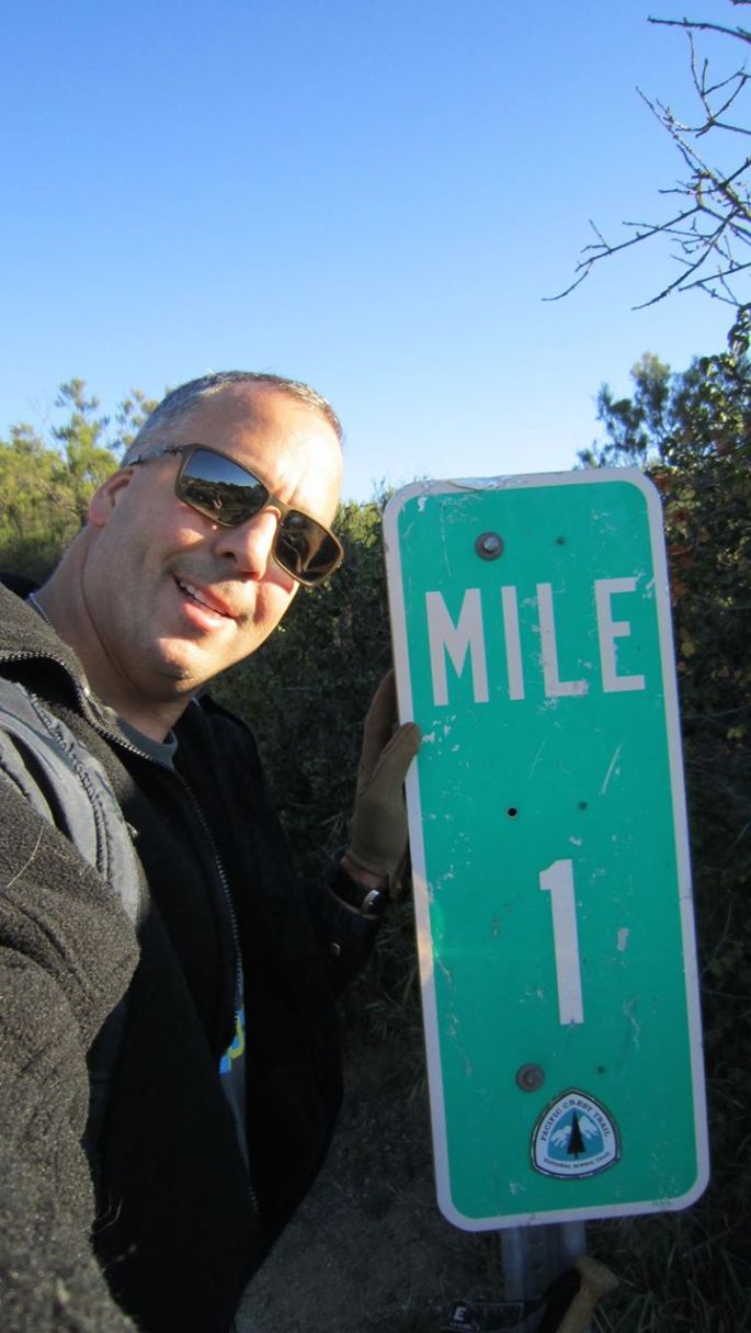
At the one mile marker I stopped to take a picture and commemorate this milestone. It would be the only mile marker I would see. Just a few feet north of the marker I would run into yet another hiker, Butterscotch. He had started his journey the night before and was still curled up in his sleeping bag. I would see him again later that day.
As the day went on and the miles passed the weather started to warm up, probably to the high 70’s. The sun made the day seem hotter and sweat was pouring from my pores. Water was a concern, so I was careful to ration it. I had started the day off with 5 liters of water and I knew that I would not have a chance to get any more until mile 15, maybe.
Roughly 4 to 5 miles into the trail I met the second hiker. She was one of the four hikers that was being dropped off when we arrived. I do not remember her name. She was an older lady who had already done a thru hike of the Appalachian Trail (AT) and was now doing 500 miles on the PCT. I stopped to rest and she passed me up. Later that afternoon I would see her again at camp.
As the day grew longer and the temperature rose I continued on the trail. At about mile nine I stopped for lunch. Finding a big boulder that was casting a two foot shadow, I grounded my pack, took my boots off and had lunch for about 45 minutes. While I was there four hikers passed me by. Of the four I would only see two again.
After lunch I set off to try to make it to camp. I had roughly six hours until sundown and six miles to go to camp. These six miles would be some of the longest miles of this trip. This would be the times that I would question my decision to hike the PCT. I doubted my ability to continue, I was physically drained and mentally defeated. To compound the problem, by mile 12 I had consumed three liters of water and had roughly two to make it the next eight. I knew that at camp I would have a chance to set up my tent and walk about another mile and a half to get water, something I was not looking forward to. And even with the water report saying there was water there, I could not trust it 100%. But I must believe.
As I arrive at mile 15.4 I arrive at Hauser Creek where I would be setting up camp. As I walk up I see some much welcome help. A trail angel has left a two liter soda bottle filled with water. On the side of the bottle was the date, 3-16, left there that day. I grab it and bring it to camp where the lady from earlier was at. Two other hikers had passed me by just a couple of miles back. A few other hikers, who were slack packed with their gear at Lake Morena, chatted for a bit and were on their way. They found two more liters of water just a few feet up the trail and left them with us. We had water, all worries were gone.
While preparing to set up camp two of the hikers that had passed me at mile nine arrived at camp. They missed the turn and walked the long way to camp. This is where I got to know Hopper, a gentleman who had moved to China to teach English. He had quit his job and sold his car, a common trend it appeared, to come to the U.S. and hike the PCT.
The older lady had already set up her tent. Hopper, his hiking companion for the day and I start to set up our tents. This was the point where Brad, not a trail name, came into camp. Brad is from Sacramento. His wife and kids dropped him off that morning at the terminus and he has until Friday April 1st to make it to Warner Springs, mile 109. That is 15 miles a day. Brad is a big guy, reminds me of Andre the Giant, and was exhausted when he arrived. He was determined.
The four of us pitched our tents, bringing the total count to five tents. This is when Butterscotch rolled in. Butterscotch is from Norther California and was taking time off from work to hike the PCT. This will be his second thru hike, with the first being the AT. He hopes to become a Triple Crown Hiker some day (thru hiking the AT, PCT and Continental Divide Trail). Butterscotch did not have a tent, just a tarp by choice. A choice that I would question a couple of days later.
That night after we had all gone to sleep, another hiker arrived. Our interaction with him was minimal. He was asking for water and we found out later that he had only two liters of water to do the first 20 miles. Shows the importance of planning and keeping up with the water reports. The next morning we would give him enough water to make it to Lake Morena.
In the middle of the night, I was woken up by a bright light. The thought rolled through my head, “who is shining that bright light at us. Well, it was not a flashlight but the moon as it came over the mountains. I pulled my beanie over my eyes and went to sleep.
27 March 2016: Trek4PTSD Day 2; mile 15.4; Hauser Creek
As the second day on the PCT started we broke camp and prepared for the 750 ft ascent to Lake Morena. This ascent is one of the steepest, if not the steepest, of California Section-A. most of the 750 foot ascent would take place in less than a mile. Starting up from the valley was not too bad, it became difficult around the half way point. That is where Hopper, who started up after I did, passed me up. The haste to get out of camp and out of the valley presented challenges getting up to the lake since I did not have a proper breakfast. The physical fatigue from the previous day and with only 1.5 liters of water for the next five miles made the ascent very difficult and taking close to four hours.
As I came closer to cresting the saddle, I could not see where that would be. That is how steep this portion of the trail was. Finally I made it to a familiar spot, the Morena Butte Trail marker. This was a welcome sight and now I knew the worst of the day was over, or so I thought. I marked this occasion on Easter Sunday by taking a selfie with the part of the trail I had just conquered behind me.
I pushed on to Lake Morena where I had the chance to have lunch, brush my teeth, get plenty of cold water and recharge my batteries for the next few miles. Here I met up with Butterscotch, Hopper, and several others once again and for the final time. I also met some more hikers while waiting to head back out.
Butterscotch decided to stay there longer and head out later to avoid the heat. He was planning to hike through part of the night, I would not see him again.
I forged on the next six miles, questioning my decision to stay on the trail even more. With every step I wanted to quit. But the support of my family and friends with the thought of those who must push through every day with the physical, mental and emotional issues of PTSD got me through yet another day.
Along the way I stopped to check my map, when I looked up I saw the most beautiful and dangerous creature of the desert. There in the middle of the trail was a SouthWestern Diamondback rattlesnake. I racked my hiking sticks and nothing. There was no room to get around it, so I decided to wait it out. While waiting I pulled out my camera and powered it on. What a beautiful picture this would make. The slithery critter was camera shy and before I could get the camera up to take its picture it slithered away while saying goodbye with its rattle. I passed the spot where it had gone in with caution and trekked on.
I arrived at the 26 mile point to make camp at Boulder Oaks Campground. When I arrived I saw a group camped out near the bathroom, I approached them and found out that it was a father with his two sons and two of their friends who had just hiked down from Laguna Mountain and were on their way to the south terminus. They invited me into their camp and I was glad for their company.
After setting up camp I walked off and turned on my phone. I became emotional after seeing everyone’s comments and the pictures of the kids doing the egg hunt. The last two days had taken their toll on my emotions and being over burdened did not help. I called my wife and mentioned that I thought about asking her to come down to take some things that were not necessary. She volunteered to drive the two hours to come get the gear and I was glad for the effort.
Waiting for my wife to arrive I had a big dinner and set aside the items I would give her. Among those items were my GoPro, kindle, GPS, Anker battery and some MRE’s I had not eaten and would not need. All those items plus a few more equaled six pounds. Those few pounds would prove to be a great help.
She arrived and we spent some time by the car. I grabbed the two Gatorade bottles that were in the car finishing one off before she left. It was time to call it a night. Saying goodbye one last time, she drove off and I settled into my sleeping bag. I hoped for a better night sleep for the next day would be a challenge. I dozed off and got some rest.
28 March 2016: Trek4PTSD Day 3; mile 26; Boulder Oaks Campground
Days one and two had been extremely challenging and in my mind day three would be the most difficult yet. So far I had only covered 26 miles, four miles behind my goal of 15 miles per day. I did not know how far I would get on this day but I set an ambitious goal of making it to Mount Laguna. I had made up my mind that I would do the best I could and if I did not make it there by night fall that was OK. However, I knew that if I did make it there I would have a choice to make. Making it the 17 miles to Mount Laguna would mean that I would stay at mile 41 or push on, possibly into the night, and make it to the Mount Laguna Campgrounds at mile 47.5. This decision was crucial since I could not set up camp between miles 41 and 53 outside of an established campground.
The challenge of the day would not be the 17 to 22 miles I would have to go that day, but the almost 3000 foot ascent. This day would be 95% uphill.
With a plan and a goal for the day I took my lighter pack filled with water and headed out. As I started off in the cool and overcast morning I said goodbye to my hosts and was off on the trail yet once again. A new rush of energy came over me and I could not help but notice the great pace of two miles an hour I was on. The thought crossed my mind of how long I could keep this pace while going up hill.
The day was nice and cool with a constant wind at my back. The views today were great and the troubles of the past two days seem to have disappeared. I trekked on and on.
Five hours into my day I stopped at mile 36, ten miles into the day. I dropped my pack and set off to have lunch and a short 30 minute break under a large oak tree. With temperatures in the low 40’s I put on my fleece and set off yet once again. My energy never faded and my spirits were high.
Today I had not seen anyone since I left camp. My only companions were the tracks of Hopper and Brad. I would hope to see them again later that day. And then I arrived at mile 41. Here I had a crucial decision to make, do I go right and keep on the PCT or right into Burnt Rancheria Campgrounds and town. From this point forward every decision I would make over the next five miles would be the wrong one.
I stayed on the PCT and shortly there after realized that there were no tracks to be found. I might have missed the chance to see my friends that night, but hoped to see them again in the next couple of days on the trail. I was sure that I had passed them at that point. I arrived at the Desert View picnic area and had a great view of the desert to the east, the last time I would see the desert that day even though I would be hiking the ridge line that would give me a better view of the desert floor below.
As I left forged on I realized that the winds that had been howling all day were picking up. I decide to put on my Frogg Toggs to act as a wind breaker since temperatures were now in the 30’s. I arrived at mile 43.4 and a road. Here I had another decision to make, do I take the road into town and stay at the lodge, do I stay on the road and hump it into the campground or do I stay on the trail and make the 4 mile hike to the campground? Again, I made the wrong decision and stayed on the trail.
By now the winds had really picked up and I could see the clouds rushing past in front of me. The decision to stay on the trail would haunt me at around mile 45. Here I reached a small saddle and the area where I should of seen the desert below. I could catch glimpses of the desert floor below as the clouds rushing past me would ease up. Here I was on the top of this mountain with a sail on my back and the thought that came over me that I might have to hunker down and try to survive the night. Scared that I would be blown off the mountain and into the desert, at least I knew that with the Spot on my pack I would be found quickly.
With fear and determination I put my head down and pushed, literally, forward. The winds gusts, I would find out later, were clocked at around 70 miles an hour. I made it past this difficult portion and kept going. With visibility dropping after a couple hundred yards I could not rely on my map for a precise location. Then, a glimmer of hope. With elation, as best as I could I yelled, “IT’S A ROAD, I SEE A ROAD.” This is when I knew that I was close to my destination and the worst was over.
As I made my way onto the road and back towards the Mount Laguna Campground my day was coming to an end, or so I thought. I walked up to the campground map and looked for a spot that was close to a bathroom, a decision that would be both good and bad. With night already setting in, I could not judge the best place to camp and chose the site closest to the restroom. Here I set up my tent and prepared to cook my dinner. The winds were too strong and I could not keep my stove lit. This is the good part about being close to the bathroom. I headed into the bathroom, which being so early in the season was very clean, and set about preparing my evening meal of Chicken Fried Rice. The warm meal did a lot for my spirits and the bathroom sheltered me from the wind. I tried to call my wife and let her know that I was OK. The day that had been so good most of the day ended up being horrible at the end.
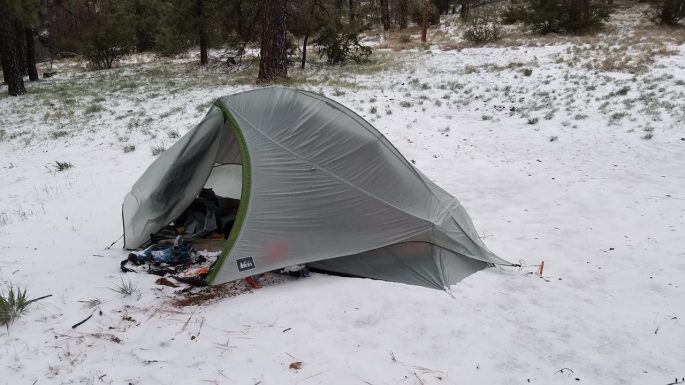
After eating dinner and texting with my wife I settled into my sleeping bag and prayed for some sleep. The high wind advisory was set until 0300 and I longed for that magic hour. I could hear what I thought was rain and the howling wind above me. At times the winds were so strong that the tent roof would be pushed down on me. As always, I had to get up in the middle of the night to go to the bathroom and I also had to fix on side of my rain fly. As I prepared to put on my foot ware I noticed what was on my shoes. I shouted, as much as I could, “Are you fucking kidding me? Frozen rain? Really?”. The winds had pushed it under the rain fly and all over my shoes. The rest of the night the winds did not ease up and sleep was not in the cards.
A great day was overshadowed by one of the most horrible nights of my life.
29 March 2016: Trek4PTSD Zero Day 1; mile 47.5; Mount Laguna Campground
As the sun rose and I could see daylight hitting my tent I had a decision to make. The winds had not let up and I was afraid of what the future might bring. The previous night I had made the decision that it would not be wise to continue the next day if the winds had not let up. Now, the faith of the day rested with the weather forecast.
I turn on my phone and look at the weather report. “High Wind Warning in effect until 3AM Wednesday”. The decision was made for me by mother nature. I would not continue on today. The decision now was what to do. Temperatures were not supposed to get much warmer and rest would be next to impossible. The decision was final.
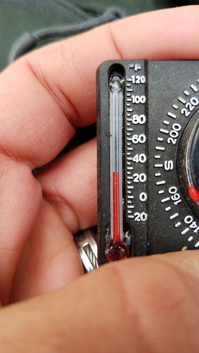
At 0630 I made the call, “I cannot get off the mountain safely, come get me”. I was suspending my trek. A wave of emotion came over me and I had my moments. It would be two more hours before I would get off this mountain. Camp was frozen, water was frozen, my cold was worse and I could not do much more.
In the meantime, I walked around the campgrounds and found two young ladies, PCTers themselves, Kristen and Haven(neither of the had trail names) from Ohio. They had taken a zero day the day prior trying to wait out the storm. They were thru hiking the PCT and had, as I, made the decision that hiking the next 30 miles was not wise. In an attempt to go on, they were going to try to find a way to Julian and continue from there. I offered them a ride there once my wife picked me up.
With camp broken and we waited for our angel to come get us of this mountain, two other hikers made it to the campgrounds. They had been caught on the ridge line behind a rock and had to wait out the night behind a huge boulder. They had hit the trail from town shortly after I had, but were unable to push through onto the campground. The decision that we had made to leave the mountain was one that these two weather beaten hikers were not struggling with. If one decided to stay and the other go we could of given them a ride. But they both decided to try to go to Julian and we could not fit them all in. They stuck together and tried to hitch a ride there.
My wonderful wife turned down the campground road and we could see a wonderful sight. As my big yellow Jeep roll in, we knew that shortly there after we would escape the 25 degree cold and windy mountain and head home for me and Julian for them.
As we turned into the main road and headed north to Julian, I stopped to say one last goodbye to the two hikers who were trying to hitch a ride there. As we made the drive north we could see portions of the trail and the ridge line it would follow. The Jeep acted like a sail and it was a struggle to keep it straight in the storm winds. This reaffirmed our decision to abandon the trail for another day.
We dropped Kristen and Haven off in Julian and headed home. As the day came to a close, I was disappointed that I was unable to continue. I knew, however, that I will pick it up where I left off in the not too distant future and the Trek for PTSD will continue.
As I was battle worn from the previous night I could not stop thinking about those I had met on the trail. Was Brad going to be able to keep his 15 mile per day pace and make it to Warner Springs in time? Was Hopper staying the night and wait out the storm? Did the two hikers who were stuck on the top of that mountain, able to get a ride to Julian? I hope that they are all doing good and OK.
I have learned a lot over the past 3 days and look forward to meeting more people on the trail. Besides the obvious hiking/camping related issues, I also learned to look at the soles of those I meet. Their soles will help me track them as I go down the trail. If I have one regret is that I did not take pictures of those I met, a mistake I will not make again. And when I am not on the trail, I will do what I can to help those that are. Plans are in the works to leave several gallons of water at mile 15.5, Hauser Creek, so that others will feel the love I did when I saw that water sitting there.
After making the decision to leave the mountain and my subsequent post, a good friend reminded me of something very important about this Trek. She said, “knowing when to ask for help is extremely important. ….isn’t this what you are promoting?” and that statement brought the whole day, and this journey, into perspective. We need to know when to swallow our pride and ask for help.
The trail is calling and I will be back on it soon at mile 47.5. The Trek will continue.


 Sunday morning came with a beautiful sunrise. My legs, which I was sure would be in knots by morning, were fresh and ready. I boiled some water and dug in my food bag for what would be breakfast. But once again, no appetite. I could not drink my coffee or eat my breakfast. With that realization, I broke camp and began heading down the mountain. I knew that in less than a mile I would have to begin another grueling ascent, something I was not looking forward to.